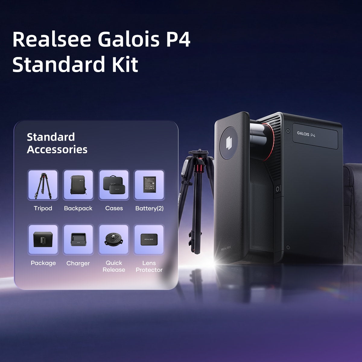
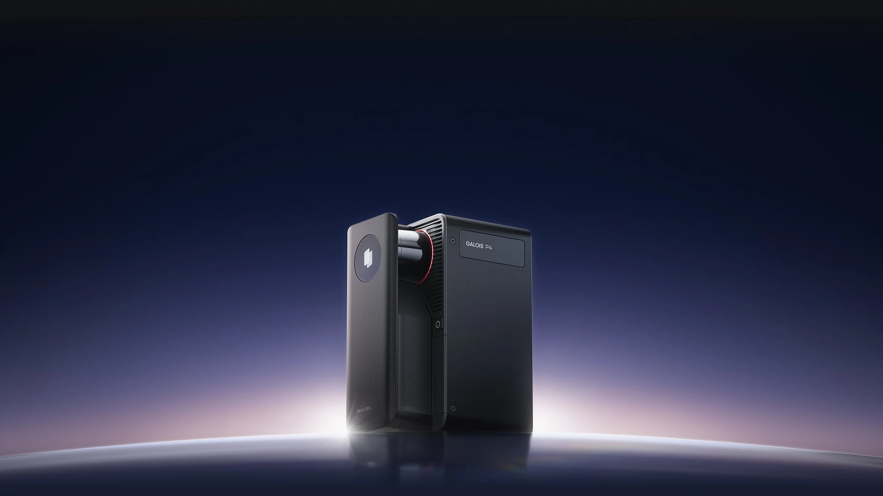
Realsee Galois P4 3D LiDAR Scanner Standard Kit

Realsee

Automated 24K 300MP 3D LiDAR Scanner
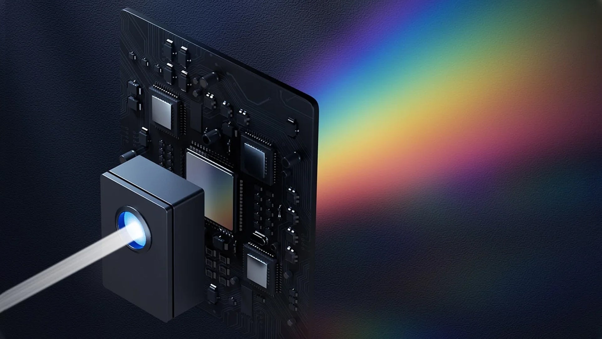
  • 905 nm Laser LiDAR
  • Radar FOV: 360° x 213.25°
  • 0.1-100m range(@90% reflectivity)
  • < ± 10 mm measurement error (@0.1-15m)
  • Scan Rate: 125,600 pts/sec
  • Camera Lens: Approx. 47MP
  • 3D Tour Resolution: 24K
  • Output pano pixels: 24576*12288 pixels
  • CMOS: 4/3 inch
  • Number of exposures per HDR frame:5
  • White Balance: Automatic
الكمية
$7,499
Realsee Payment Methods
MastercardVisaAmerican Express PayPalMaestroShop Pay Google Pay
Circular cropped portrait of a smiling young East Asian woman against a clear blue skyThree people in different sports gear in separate circular frames on light blue background
Need help shopping?
Contact us to purchase more points.
Chat Now

Multiple applications

Galois P4 3D LiDAR Scanner

Ultimate LiDAR tool for any-space immersive 3D tours

Built to Set the Standard

The Galois P4 Advantages

Realsee Galois P4 3D LiDAR scanner mounted on tripod, showing 16-second fast scanningRealsee Galois P4 3D lidar scanner for construction, mounted on tripod for professional 3D spatial scanning

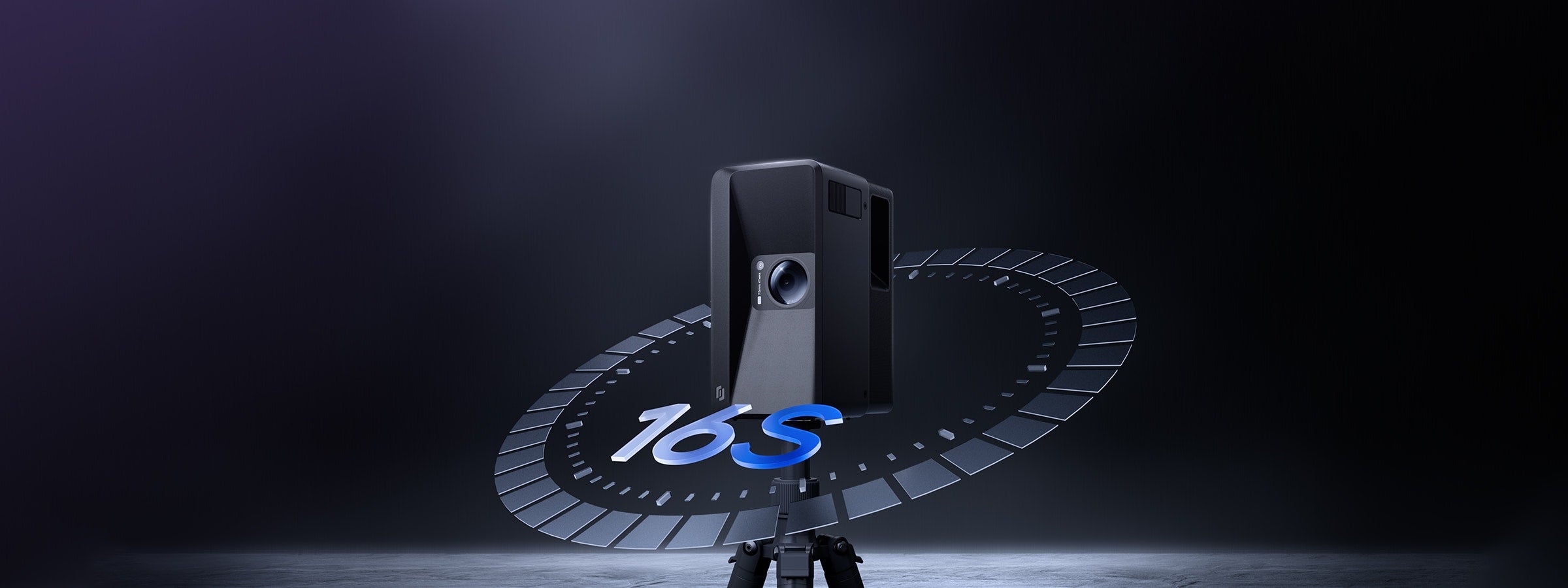
16s Ultra-fast Scanning

16-second lap ultra-fast scanning per scan point, doubling efficiency.

Close-up of the 47MP lens on Realsee Galois P4 3D LiDAR scanner for constructionClose-up of the lens on Realsee Galois P4 3D LiDAR scanner for real estate

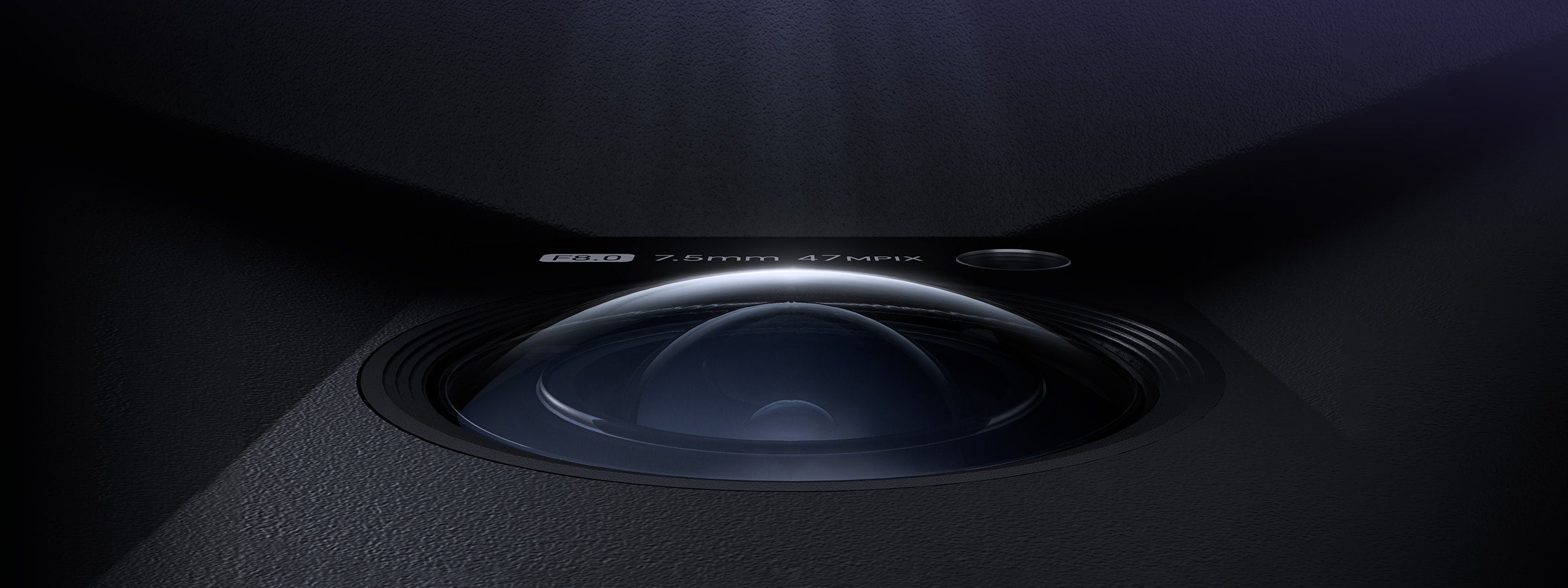
300-megapixel, 24K HD

47-megapixel lens, revealing every details
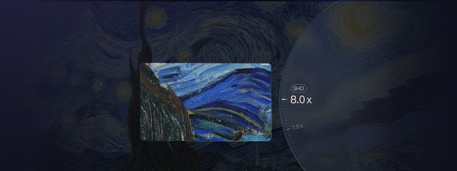
Realsee Galois P4 3D LiDAR scanner for real estate 8x zoom demo showing high-resolution imagingRealsee Galois P4 3D LiDAR scanner mobile app showing high-resolution capture results

8X Lossless Zoom

Infinite zoom, unparalleled clarity

Realsee Galois P4 professional 3D LiDAR scanner for construction and real estate scanningClose-up of Realsee Galois P4 professional 3D LiDAR scanner for construction

100-meter Scanning Radius

905 nm LiDAR, broader range

Outdoor construction site point cloud captured by Realsee Galois P4 3D LiDAR scanner for construction3D point cloud indoor space captured by Realsee Galois P4 3D LiDAR Scanner for construction

125600 Point Clouds/Second

Larger-scale high-quality dense point cloud

Realsee Galois P4 professional 3D LiDAR scanner for construction and real estate 3D space scanning

Clarity. Precision. Speed.

Realsee Galois 3D LiDAR Scanner P4

Combining a high-density point cloud LiDAR scanner with 24K ultra‑high‑definition 3D reconstruction, Galois P4 delivers 300‑megapixel imagery, 125,600 points per second, and a 16‑second single‑shot capture cycle — setting a new industry standard.

Realsee Galois P4 3D LiDAR scanner for construction mounted on tripod for on-site spatial scanning

Compact and Portable Design

At just 2.6 kg (5.73 lbs, including battery) including battery, Galois is remarkably lightweight and compact, making transportation and on-site handling effortless.

Realsee Galois P4 3D LiDAR scanner for real estate, premium bundle with all accessories

Complete Kit, Ready to Scan

The Galois 3D LiDAR Camera Kit includes all essential accessories: Tripod, Backpack, Lens Cap, LiDAR Cover, Charging Kit, and 3 Battery.

Realsee Galois P4 professional 3D LiDAR scanner for construction

Power Through the Day

Galois charges fully in just 2.5 hours and delivers up to 3 hours of continuous scanning, keeping your projects moving without interruption.

Built on Proof. Proven at Scale.

Realsee Galois M2 and Galois P4 3D LiDAR scanner for real estate with award-winning industrial design

Galois is not a first-generation device. From M2 to P2 to P4, each iteration reflects years of field experience and engineering refinement.

The series has been internationally recognized with awards such as the Red Dot Design Award and the Good Design Award (G-Mark), highlighting both industrial design excellence and product performance.

Realsee Galois P4 professional 3D LiDAR scanner for real estate, over 10,000 units deployed globally

With approximately 10,000 units deployed worldwide, the Galois series is actively used across multiple industries.

it is a commercially proven system already embedded in real production workflows.

Realsee Galois P4 3D LiDAR scanner for real estate with proven real-world capture performance

Over 58 million spaces have been captured, covering more than 4.8 billion square meters. These are not controlled benchmarks or lab results — they reflect continuous real-world usage across diverse environments where accuracy and reliability are critical.

Realsee Galois P4 3D LiDAR Scanner, trusted professional cross-industry lidar scanner for construction

Realsee solutions are used in over 70 countries by more than 5,000 brands across real estate, construction, tourism, and other industries.

Galois technology has been deployed in museums, universities, and public institutions, and showcased at global events such as WAIC. Core technologies have also been presented at leading academic conferences including ICCV.

Realsee Galois P4 3D LiDAR scanner workflow background for professional 3D virtual toursMobile layout background for Realsee Galois P4 professional 3D scanning workflow

Perfect Visuals, Flawless Quality

Galois P4 presents ultra-high-definition visuals, achieving unparalleled realism that captures every detail and immerses you in every single capture

RealseeRealsee

Galois P4 is equipped with a next-generation 4/3-inch CMOS sensor and a 47-megapixel high-resolution color lens module, directly generating stunning 300-megapixel ultra-high-definition panoramic images that set the industry benchmark for picture quality.

RealseeRealsee

Galois P4 redefines the limits of VR clarity with its 8x lossless zoom technology. Distant window views feel as if you're right before the glass, while microscopic structures reveal sharply defined edges. From sweeping vistas to the finest details, everything comes under your crystal-clear command.

Core LiDAR sensor module of Realsee Galois P4 professional lidar scanner for constructionRealsee Galois P4 3D LiDAR scanner module emitting scanning laser for construction

Galois P4 is equipped with a built-in multispectral sensor that captures the reflective information of objects across specific wavelengths, including visible light and near-infrared. This technology significantly enhances the authenticity of image colors and details while revealing hidden features invisible to the human eye.

RealseeRealsee

The HDR technology of the Galois P4 delivers a balanced world of light and shadow that closely mirrors real human vision—highlights remain vivid without overexposure, shadows retain rich detail, and every inch of space you explore feels authentic and tangible.

Realsee Galois P4 3D LiDAR scanner workflow background for professional 3D virtual toursMobile layout background for Realsee Galois P4 professional 3D scanning workflow

One Scan Multiple Outputs

Dark blue gradient background for Realsee Galois P4 3D LiDAR scanner product page

Speed That Sets a New Standard

Galois P4 delivers instant response and a zero-learning-curve experience — redefining what efficiency means in 3D capture.

Realsee Galois P4 lidar scanner for construction supports co-capture by multiple photographers scanning different floors
Point. Move. Done.

No complex setup. No training required. Just point and move to start capturing — anyone can do it.

16 Seconds. 1 Second. Done.

A full scan takes only 16 seconds, with point-to-point stitching completed in just 1 second—doubling the efficiency of capture workflows. With Galois P4, a 100㎡ space can be fully captured in just 8 minutes.

Co-Capture

It supports multi-user partitioned parallel capture, enabling synchronized and efficient progress. Data is automatically and seamlessly stitched into a unified project, simplifying the handling of large-scale spaces and significantly accelerating

Realsee Galois P4 lidar scanner for construction supports co-capture by multiple photographers scanning different floors
High-definition Touchscreen

No phone control needed — lift, tap, and capture blind with one touch for even simpler operation

Realsee Galois P4 lidar scanner for construction supports co-capture by multiple photographers scanning different floors
Realsee Galois P4 3D LiDAR scanner workflow background for professional 3D virtual toursMobile layout background for Realsee Galois P4 professional 3D scanning workflow

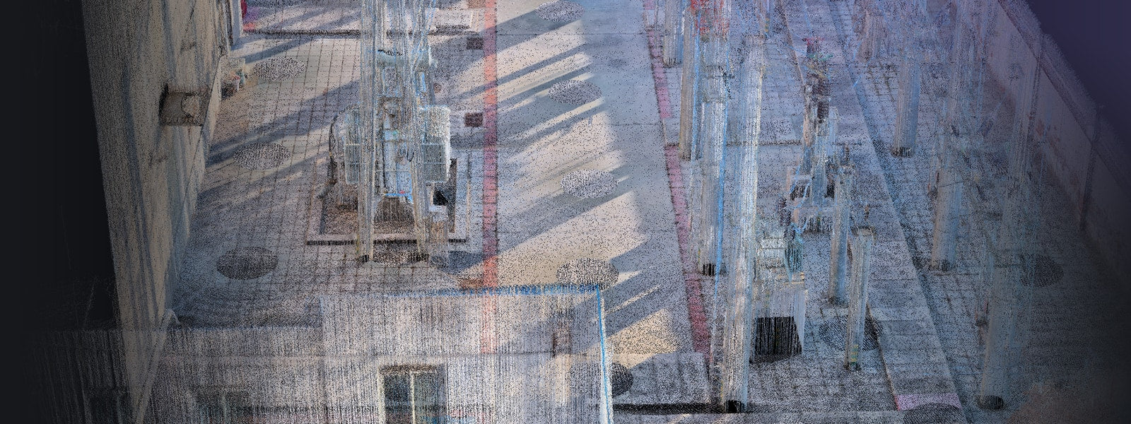
Scan Farther. Capture Denser. View Wider

Galois P4 combines long-range deep detection, dense point capture, and a wide field of view to reveal the intricate textures of the world with ultimate spatial precision

Realsee Galois P4 professional 3D LiDAR scanner for real estate captures dense indoor point clouds
Realsee Galois P4 3D LiDAR scanner on tripod demonstrating its 213.25° wide scanning field
Scan Far——100-meter scanning radius

Galois P4 extends its capture range up to 100 meters, delivering greater spatial penetration and deeper detection for higher precision in spatial understanding—empowering decisions that reach as far as your scan.

Capture dense—125600 point clouds/s

Equipped with a 905nm LiDAR, the Galois P4 captures 125.6k point clouds/s, enabling the collection of highly detailed 3D spatial data. Every nuance of space is revealed through its dense and precise point cloud—leaving no detail unseen.

Realsee Galois P4 professional 3D LiDAR scanner for real estate captures dense indoor point clouds
Wide perspective — 360° × 213.25° FOV.

Galois P4 breaks scanning boundaries with a massive 360° × 213.25° field of view, covering wider areas and leaving no blind spots—delivering truly higher efficiency and more complete capture.

Realsee Galois P4 3D LiDAR scanner on tripod demonstrating its 213.25° wide scanning field
Realsee Galois P4 professional 3D LiDAR scanner for real estate captures dense indoor point clouds
Realsee Galois P4 3D LiDAR scanner on tripod demonstrating its 213.25° wide scanning field
Realsee Galois P4 3D LiDAR scanner workflow background for professional 3D virtual toursMobile layout background for Realsee Galois P4 professional 3D scanning workflow

Technical Specifications

Realsee Galois P4 scan-to-BIM workflow background for 3D spatial data captureMobile layout background for Realsee Galois P4 professional 3D scanning workflow

Contact Us

Blue overlapping chat bubble feature icon for 3D LiDAR scanner for real estate
CHAT
Office Hours: 24/7
Started Now
Green WhatsApp contact icon for customer communication on Realsee product page
WhatsApp
@Realsee
Started Now
Blue translucent envelope email icon with document inside
Email
hello@realsee.ai
Started Now
Blue glossy folded document icon for Realsee Galois P4 3D LiDAR scanner for real estate
Contact Us
Submit Your Requests
Contact Us Now
Dark blue product section background for Realsee Galois P4 3D LiDAR scannerDark blue gradient solid placeholder background for 3D LiDAR scanner product page