


From gated cloud ecosystems to operational agility: How commercial brokerages scale property marketing and spatial planning using surveying-grade Galois LiDAR without recurring active space caps.
Executive Summary
Following CoStar Group’s acquisition of Matterport, the virtual tour market has split into two camps: closed marketplaces prioritizing recurring subscriptions, and open reality capture platforms prioritizing operational flexibility. For commercial real estate (CRE) teams, Realsee provides the benchmark alternative in 2026. It matches Matterport’s surveying-grade fidelity through dedicated Galois M2 and P4 LiDAR hardware, but replaces active-space hosting lock-ins with a pay-as-you-go model, un-paywalled 3D data exports for tenant fit-outs, and a free built-in floor plan editor.
1. Dedicated Hardware Benchmark: Realsee Galois vs. Matterport Pro3
Commercial real estate demands hardware that thrives in complex architectural environments: open-concept office floors, double-height atriums, sunny retail storefronts, and logistics warehouses spanning tens of thousands of square feet.
Matterport Pro3
- Outdoor Range: Up to 100m in direct sunlight
- Scan Cycle: Approx. 20s per capture point
- Limitation: High unit pricing paired with ongoing per-space hosting overhead
Realsee Galois M2
- Image Quality: 16K panoramic digital twin fidelity
- LiDAR Geometry: Continuous indoor/outdoor registration
- Application: Fast-paced retail turnover, boutique offices, and hospitality
Realsee Galois P4
- Survey Precision: Millimeter-level (sub-10mm) accuracy with 100m range
- Speed Advantage: Ultra-fast 16-second single scan rotation
- Visual Clarity: 24K HDR panoramas powered by a 4/3-inch sensor
Watch professional property photographer Jonathan Shilton test Realsee’s LiDAR hardware workflow, comparing Dollhouse mesh reconstruction, scan speed, and software flexibility against legacy Matterport systems.
2. Unified Platform Comparison Matrix (2026)
| Evaluation Category | Realsee Platform | Matterport Ecosystem |
|---|---|---|
| Pricing Architecture | True Pay-As-You-Go; zero penalties for archived portfolios | Tiered recurring subscriptions capped by Active Spaces |
| Hardware Fleet | Galois M2 (16K digital twin) & Galois P4 (24K, 100m range LiDAR) | Matterport Pro2 (Structured Light) and Pro3 ($5,995+ LiDAR) |
| Capture Speed | 16 seconds per station (Galois P4); rapid multi-point registration | ~20–30 seconds per station; deliberate alignment cycles |
| Schematic Floor Plans | AI-drafted + Free interactive Floor Plan Editor for layout revisions | Paid recurring add-on ($15–$25+ per unit); turnaround latency |
| 3D Design & CAD Handoff | Direct export of point clouds (E57, PLY) and 3D files for design workflows | Matterport Cloud only; raw data export locked behind MatterPak fees |
| Field Efficiency | App-Free standalone capture option + Video Fusion technology | Matterport Capture app dependency; static Mattertag markers |
3. Operational Economics: Breaking the "Active Space" Tax
Commercial real estate portfolios are inherently fluid. Under Matterport’s subscription tiers, you pay a steep monthly retainer for "Active Spaces" even when listings are leased or dormant.
True Pay-As-You-Go Freedom
Realsee operates on a predictable pay-as-you-go structure. Brokerages maintain an accessible historical record of all completed property scans without recurring monthly subscription creep or forced archiving penalties.
AI Floor Plans with Free In-House Editing
While AI automatically drafts 2D and 3D schematics from scans, complex commercial layouts often require minor adjustments. Realsee provides a free, browser-based Floor Plan Editor so marketing teams can adjust square footage annotations, tweak room names, and export polished PDFs without waiting 48 hours for paid manual drafting revisions.
4. Tenant Space Planning & Video Fusion Marketing
Closing a commercial lease often requires resolving layout logistics and helping prospective tenants visualize empty or raw space (white-box shell).
Export 3D spatial models directly into Blender, 3ds Max, or Unreal Engine to present fully furnished office fit-out concepts to corporate tenants.
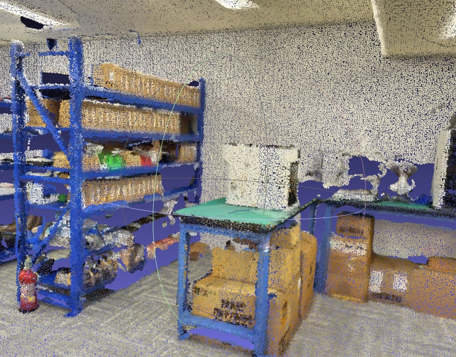
Dense point cloud files (E57, PLY) feed directly into AutoCAD and Revit to confirm mechanical clearances and verify spatial boundaries during lease negotiations.
Embed transparent-background presenter video directly into the virtual walkthrough to have your listing agent welcome visitors in the 3D space.
5. The Verdict: Aligning Your Spatial Stack for 2026
Where Realsee Fits Best:
- Operational Cost Discipline: You need surveying-grade LiDAR without recurring monthly subscription penalties for historical listing storage.
- Rapid Site Surveying: Large 100m spaces and high-glare outdoor retail plazas need to be scanned in 16 seconds per spot.
- Unrestricted Spatial Data: You want direct downloads of 3D models and point clouds for tenant fit-out planning and virtual staging.
- Agile Floor Plans: You require fast AI-drafted schematics backed by a free built-in editor for layout changes.
Where Matterport Fits Best:
- Client agreements or institutional guidelines explicitly mandate delivery through a Matterport-hosted URL.
- Your current workflow is built around existing enterprise software pipelines linked solely to Matterport’s proprietary cloud API.
Frequently Asked Questions
Can Realsee point clouds and 3D models be used in Revit and Blender?
Yes. Realsee provides direct downloads of standard point clouds (E57, PLY) and textured 3D models. These integrate directly with Autodesk Revit, AutoCAD, Blender, and Unreal Engine for architectural coordination, measured lease drawings, and virtual tenant staging.
How does Realsee handle floor plan revisions?
Realsee’s AI automatically extracts 2D and 3D floor plans from LiDAR capture. If unique walls or custom partitions need adjustments, users can refine and export them using Realsee's free web-based Floor Plan Editor without paying extra drafting fees.
Does Realsee charge per-month fees for archived properties?
No. Realsee uses a pay-as-you-go commercial framework with no active-space limits. This allows brokerages to maintain an accessible historical archive of scanned properties without triggering higher monthly subscription tiers.