


Reviewer: PhotoJoseph, specializing in camera reviews, tutorials, and professional imaging workflows, is based in Slovenia
Experience: The PhotoJoseph channel is all about the camera: photography, video and cinematography, live streaming, lighting, microphones, drones…
——————————
The video provides an in-depth review and demonstration of the Realsee Galois P4, the latest iteration of Realsee’s 360-degree LiDAR camera tailored for the Architecture, Engineering, Construction (AEC), and Real Estate markets.
Building upon the previous Galois M2 model, the P4 delivers significant advancements such as double the scanning speed, up to 7 times more point cloud data capture, and the ability to operate independently without phone connectivity.
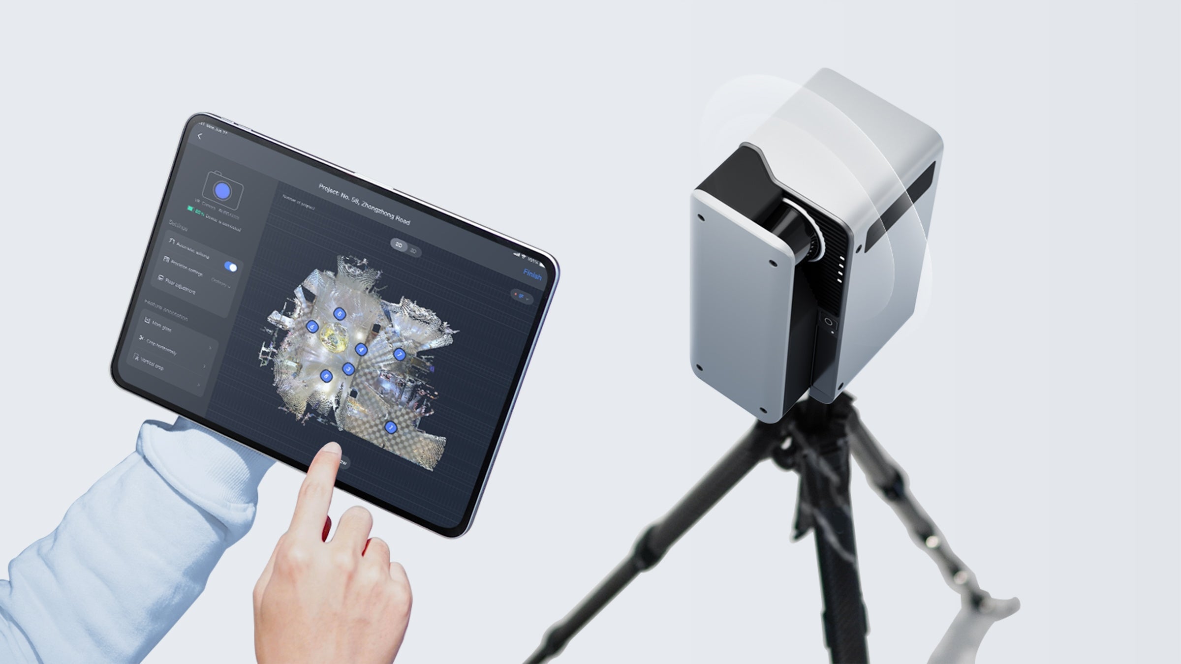
The reviewer walks through the unboxing, setup, and operation process, highlighting how intuitive the camera is with its improved tripod and magnetic lens cap. A major usability upgrade is the ability to scan without needing the app, which speeds up the workflow for experienced users.
The video also details key technical improvements: an expanded LiDAR range of up to 100 meters with enhanced accuracy, and vastly richer point cloud data (125,600 points in P4vs. 18,600 in M2), enabling more detailed models and fewer scans per property. Battery size is slightly reduced, but scanning is faster, allowing for whole-home scans on a single charge, with two batteries included.

The walkthrough includes a practical scanning session, discussing steps to ensure model accuracy, such as overlapping scan points for seamless stitching. The reviewer encounters a scenario where a scan area has no visibility to previous points, explaining how to identify missed scans using the app and fill gaps efficiently during a follow-up scan.
Data import, error handling, and final model processing via cellular network are also demonstrated. The finished models showcase stunning 360-degree panoramic tours with a significant boost in resolution—from 20 megapixels to 47 megapixels—allowing much deeper zoom and higher quality imagery. Additional upgrades include the ability to download 300 megapixel panoramic files with a wider 145-degree field of view, compared to previous models.
Pricing is addressed candidly: at $7,499, the Realsee Galois P4 is positioned as a professional tool rather than a casual camera, ideal for high-end real estate or large-scale projects. Its value proposition lies in its comprehensive integrated system—detailed 3D data, floor plans, dollhouse views, and 360 tours—without recurring subscription fees, only charging for hosting and high-level 3D outputs.
——————————————————————————————————————————————
Highlights
-
📸 The Realsee Galois P4 scans twice as fast and captures up to 7x more data than its predecessor.
-
🆓 Scanning can now be done app-free, allowing independent operation without a connected phone.
-
📏 The LiDAR range increased to 100 meters with 10mm accuracy, enabling fewer scan points for larger spaces.

-
🔋 Despite a smaller battery size, faster scanning speed allows whole property scans on a single battery, with two batteries included.
-
🖼️ The final 360-degree images are 47 megapixels, supporting up to 8× zoom with exceptional clarity.
-
💰 The $7,499 camera requires no recurring subscriptions; fees only apply for hosting and advanced 3D exports.
-
🏛️ The camera is versatile, applicable not only for real estate but also for public virtual tours such as museums.
Key Insights
-
🚀 Significant Performance Leap: The P4’s ability to scan at double speed and gather nearly seven times more data means dramatically improved efficiency and detail in 3D scanning workflows. This addresses key pain points in large property scanning by reducing total time and the number of required scan points. For professionals managing multiple properties or large buildings, this is a game-changer.
-
🔄 App-Free Operation Enhances Flexibility: Allowing scans without phone or tablet connection removes a logistical bottleneck and streamlines the scanning process. However, this requires the user to have prior experience with the app-based method to ensure coverage since the app assists with visual scan planning. The blend of app and app-free scanning caters to both beginners and advanced users.

-
📡 Extended LiDAR Range with Higher Accuracy: The jump to a 100-meter range and accuracy of 10mm (from 20mm) increases the camera’s applicability to open and large indoor environments, reducing the number of necessary scan points and improving data quality. This results in more accurate models and less labor-intensive capture cycles.
-
📊 Massive Increase in Data Density Bolsters Model Quality: The point cloud’s growth from 18,600 to 125,600 points per scan implies vastly richer 3D models. This is critical for users needing detailed exports for CAD, BIM, or architectural analysis, offering broader professional utility beyond immersive tours.
-
💼 No Subscription Fees Provide Cost Transparency: Unlike many competitors that charge monthly or recurring fees for software access, Realsee’s model only bills for hosting and select exports, reducing ongoing costs. This transparent, pay-as-you-go model aligns with professional workflows and budgets, making it easier to scale use without unexpected expenses.
-
🌆 High-Resolution Panoramas Expand Viewer Experience: The jump to 47MP panoramas with an 8× zoom capability enhances the virtual tour’s immersive feel and detail, making these tours more compelling for buyers or clients. The increased field of view (from 135° to 145°) provides a broader, more engaging perspective. This helps real estate agents and AEC professionals to present properties more impressively.
-
🤝 Broader Applications Beyond Real Estate: The partnership example with the City of Maribor underscores the camera’s adaptability for cultural and public projects like museums and theaters. This indicates the potential for expanding 3D scanning technology into public heritage, tourism, and educational sectors, broadening its market reach.
This thorough review of the Realsee Galois P4 demonstrates a blend of usability, technical sophistication, and value that positions it as a leading choice for professionals seeking high-precision, efficient 3D reality capture in both real estate and beyond.