Using Realsee + Google Street View to Elevate Commercial Leasing and 3D Photography Projects
As hybrid work and remote decision‑making become the norm, potential tenants and clients increasingly rely on online spatial experiences to evaluate commercial and rental properties. For landlords, asset managers, and 3D photography teams, this creates a new opportunity: turning high‑quality 3D tours into discoverable digital assets on Google Maps and Google Street View (GSV).
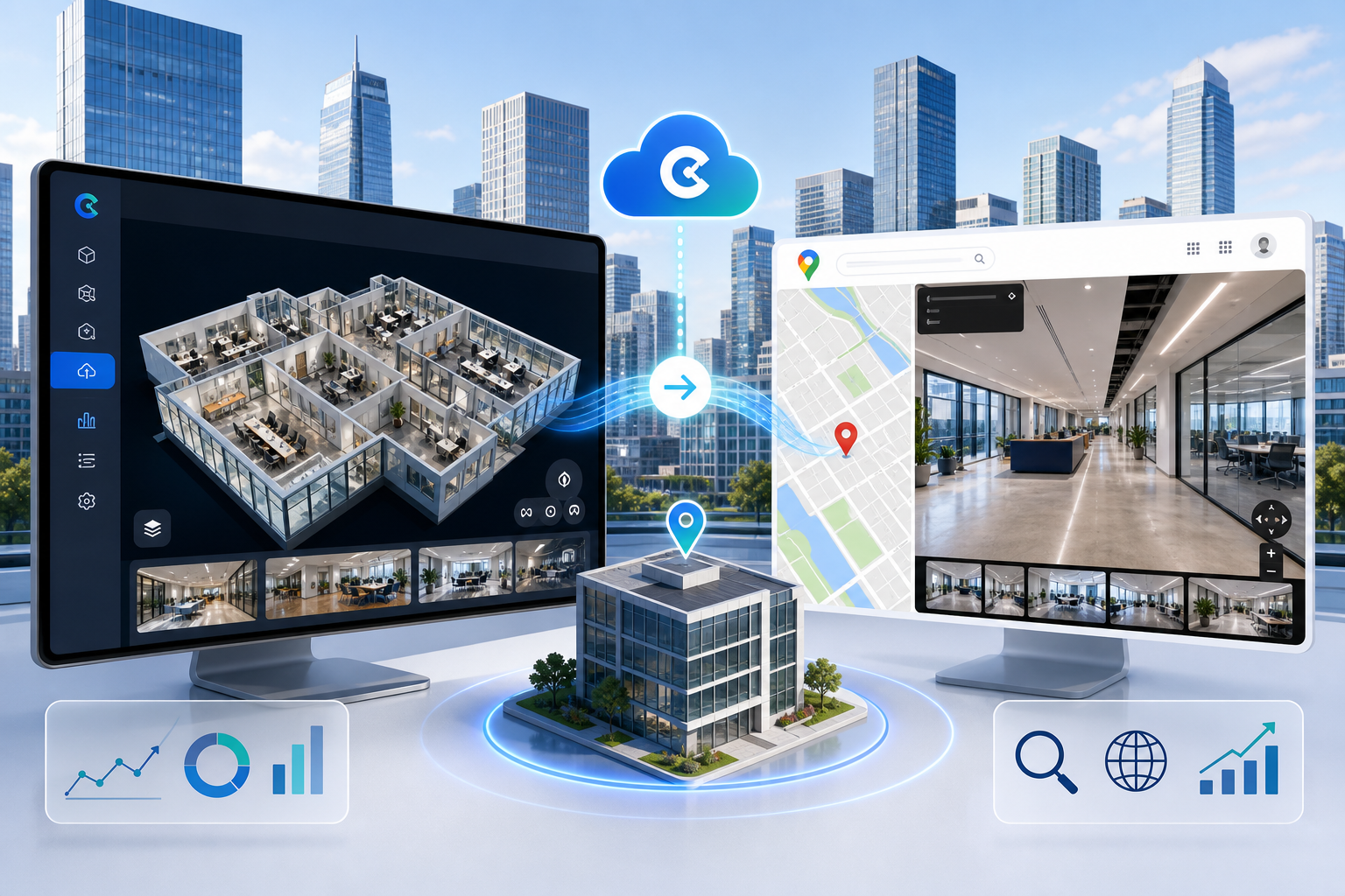
With Realsee’s native one‑click integration to Google Street View, you can publish 3D digital twins of eligible commercial and rental properties as fully navigable Street View experiences, directly connected to your Google Maps listing. This article explains how Realsee + GSV can improve leasing efficiency, enhance space presentation, and increase the delivery value of 3D photography projects—without implying separate SEO or marketing services.

Why Realsee + GSV Matters for Commercial and Rental Properties
1. Show Your Space Where Prospects Actually Search
When potential tenants look for offices, retail units, hospitality venues, or industrial spaces, their journey often starts on Google Maps:
-
They search for areas, business districts, or specific buildings.
-
They open Street View to understand the surroundings, entrances, and access.
-
They scan photos and basic information to decide whether to engage further.
By publishing a Realsee commercial or rental project to GSV, your map pin becomes more than a static marker—it becomes a space that prospects can actually walk through and explore.
Before contacting your leasing team, visitors can virtually move through the lobby, corridors, typical floors, and shared areas to build a complete picture of the property.
2. Shorten Decision Cycles and Reduce Low‑Intent Site Visits
High‑intent commercial prospects care about very specific questions:
-
What does the floor plate and usable area look like?
-
Does the entrance and reception experience match their brand image?
-
How is natural light and visibility in key work or customer areas?
-
Where are shared amenities, elevators, and restrooms located?
Realsee 3D tours, combined with GSV, can answer these questions in minutes. As a result:
-
Early‑stage, low‑intent site visits that don’t convert are reduced.
-
Leasing teams spend more time with prospects who already understand the space.
-
Tenants and brokers can share the GSV tour internally to align multiple stakeholders faster.
3. Strengthen Digital Perception and Transparency
In competitive commercial markets, professionalism and transparency matter:
-
A building with a professionally captured 3D tour published on GSV signals that it is modern, inspection‑ready, and well managed.
-
Asset managers can highlight upgrades, signage, and design details that static photos struggle to convey.
By combining Realsee’s high‑fidelity 3D capture with GSV’s reach, you make your assets easier to see, easier to understand, and easier to choose in digital channels.
How Realsee + GSV Adds Value to 3D Photography Projects
1. Include “Publish to GSV” as Part of Project Delivery
If you already provide 3D capture or virtual tours for commercial clients, Realsee’s GSV publishing capability can become an important part of your project deliverables:
-
Capture the space on site and create a Realsee 3D tour.
-
In Realsee Console, complete address alignment, account authorization, and project activation.
-
Use Realsee’s native ability to publish eligible commercial and rental projects to Google Street View in one workflow.
This means you’re not only delivering “a link or a file”, but a space experience that works directly inside Google Maps / Street View, increasing the perceived value of the project.
2. Build a Public Portfolio on Google Maps
Each project published to GSV can become part of your public portfolio:
-
You can showcase office buildings, retail complexes, showrooms, and venues using live GSV links.
-
Prospective clients experience your work in real contexts, not just via screenshots or highlight videos.
As more spaces go online with your support, you establish yourself as a local specialist for Realsee + GSV implementations.
3. Differentiate from Traditional Static Photography
Static photography remains important, but has inherent limits:
-
It captures a single angle, not full navigation and flow.
-
It lacks interactive exploration and spatial structure.
-
It is typically disconnected from Maps‑based discovery.
By integrating Realsee 3D tours and GSV publishing into your projects, you act as a spatial experience builder, not just a photo provider.
This helps you:
-
Increase the persuasive power of each project.
-
Offer more consistent digital space presentations across a client’s portfolio.
From Capture to Display: The Realsee + GSV Workflow
For commercial owners and service providers, the Realsee + GSV workflow is clear and repeatable:
-
Capture the space with Realsee
Scan the target commercial or rental property using Realsee’s standard 3D workflow to generate a high‑quality tour. -
Prepare the project in Realsee Console
-
Ensure the project status is Active.
-
Confirm building names, floor labels, and basic metadata.
-
-
Publish to Google Street View in Realsee Console
-
Open the project’s Google Street View tab.
-
Align the 3D floor plan footprint with the actual building location and outline on Google Maps.
-
Connect the appropriate Google account and check the permission to “Publish on Google Street View”.
-
Submit the upload and allow processing time.
-
-
Integrate the GSV link into leasing and marketing workflows
-
Add the GSV link to property websites, leasing brochures, broker decks, and email campaigns.
-
Include it as part of the asset information package for brokers, asset managers, and prospective tenants.
-
-
Refine space presentation based on feedback
-
Monitor inquiries, client feedback, and internal usage.
-
Adjust how you present spaces and where you place calls‑to‑action (e.g., book a tour, download floor plans) around the tour.
-
For technical details, scan spot recommendations, and troubleshooting, refer to the full guide: How to Upload a Realsee Project to Google Street View
Example Commercial Use Cases
Office Buildings and Business Parks
Owners can capture and publish:
-
Lobbies and reception areas
-
Typical office floors and sample fit‑outs
-
Shared meeting spaces, lounges, and amenities
Once these tours are linked to the building’s Google Maps listing, brokers can reference GSV links in proposals, and tenants can share them internally to support shortlisting.
Result: fewer low‑intent “just looking” visits, and faster formation of qualified shortlists.
Retail Complexes and Showrooms
Operators can capture and publish:
-
Main customer circulation corridors
-
Key brand stores and public areas
-
Event and display zones
Prospective brands can use the GSV tour to understand actual traffic flows, sightlines, and neighboring tenants, making negotiations more efficient and storytelling more concrete for leasing teams.
Hospitality and Experience‑Based Venues
Hotels, venues, and experiential spaces can capture:
-
Entrances, lobbies, and public circulation
-
Meeting rooms, event halls, and F&B areas
When these spaces are presented through Realsee + GSV, guests and planners gain a clearer understanding of layout and flow remotely, which supports more confident bookings and reduces the need for repeated site inspections.
Property Type Scope
Realsee’s Google Street View publishing workflow is designed primarily for commercial and rental properties, such as:
-
Office buildings and business parks
-
Retail spaces and shopping centers
-
Hotels, venues, and experiential locations
-
Professionally managed multi‑unit rental assets
Privately owned, purely owner‑occupied residential homes may be subject to additional Google policies and local privacy regulations, and are not the recommended use case for this integration.
If you are unsure whether a property type is appropriate for GSV publishing, consult your legal/privacy team and Google’s official Street View guidelines before proceeding.
Getting Started with Realsee + GSV
If you want to pilot Realsee + GSV for your commercial assets or 3D photography projects, we suggest:
-
Selecting one representative commercial or rental property with a clear need for digital presentation.
-
Defining objectives (e.g., improving qualified inquiries, supporting brokers, increasing project delivery value).
-
Comparing inquiries and feedback before and after publishing to evaluate impact.
To dive into the technical side of publishing, visit our Help Center:
-
Why this feature matters:
New Feature: One‑Click Publishing from Realsee 3D Tours to Google Street View -
How to publish step by step:
How to Upload a Realsee Project to Google Street View