


Real estate photography deliverables
3D Real Estate Photography: What It Is and How Photographers Can Deliver More from One Shoot
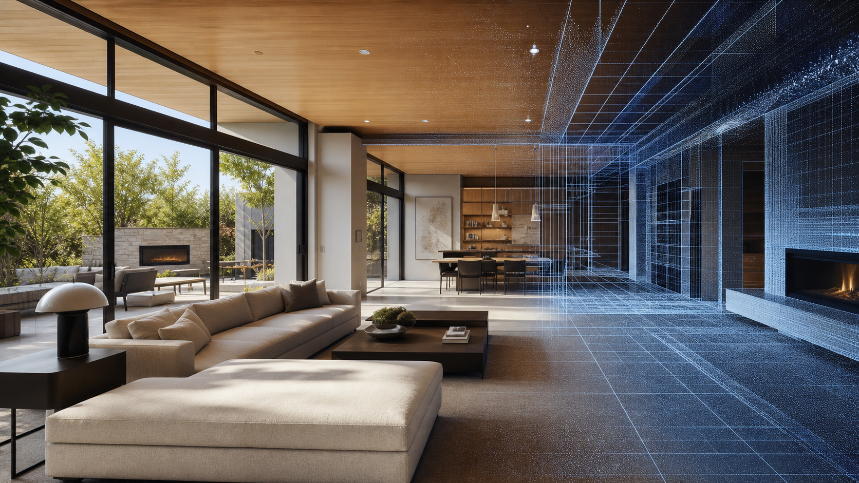
Real estate photography is moving from basic listing photos toward full property media packages. Agents, brokers, developers, and property owners increasingly want 3D tours, panoramas, floor plans, snapshots, point clouds, 3D models, and CAD-related outputs that help them market, inspect, document, and reuse a property digitally.
For photographers, that shift creates a practical question: how do you add 3D capture without turning every shoot into several disconnected workflows? This guide explains what a 3D real estate photography workflow means, where 3D capture fits, what deliverables can come from one property visit, and when a professional 3D LiDAR camera such as Galois P4 makes sense.
What Is 3D Real Estate Photography?
3D real estate photography is not simply "photos in 3D." It is a spatial capture workflow that records a property so viewers can move through the space and so the captured data can support additional deliverables. Depending on the capture method and platform, those deliverables may include an interactive 3D tour, high-resolution panoramas, marketing snapshots, floor plans, point clouds, 3D models, and CAD-related outputs.
Traditional photography still matters. Listing photos remain essential for portals, brochures, and social posts. The difference is that 3D capture can turn one site visit into a reusable property media package.
Traditional Photos
Best ForFast listing coverage, hero images, exterior/interior stills
Typical OutputsEdited JPGs, listing galleries, social images
Where Galois P4 FitsNot the primary tool; photographers may still deliver photos alongside a 3D package.
360 Tours
Best ForBasic remote viewing and simple walkthrough experiences
Typical Outputs360 panoramas, virtual tour links
Where Galois P4 FitsUseful comparison point; P4 is for teams that need LiDAR-backed spatial data and higher-value outputs.
3D Real Estate Photography
Best ForProperty media packages that combine viewing, marketing, and documentation
Typical Outputs3D tours, panoramas, snapshots, floor plans, videos, shareable links
Where Galois P4 FitsP4 supports professional capture when visual quality and spatial data both matter.
3D LiDAR Capture
Best ForPremium residential, commercial, AEC-adjacent, and reusable spatial documentation workflows
Typical Outputs3D tours, point clouds, 3D models, CAD-related outputs, floor plans, snapshots
Where Galois P4 FitsP4 is positioned as a professional 3D LiDAR camera/scanner for these workflows.
Why Real Estate Photography Is Moving Beyond Photos
Property marketing now happens before many buyers or stakeholders ever visit in person. A strong image gallery is still useful, but many clients want a richer sense of layout, scale, flow, and condition. That is why real estate photography deliverables are expanding.
For agents and brokers, 3D tours support remote viewing and help a listing feel more complete online. For developers and property owners, the same capture can support marketing review, stakeholder communication, leasing, renovation planning, or documentation. For photographers, the opportunity is to package more value from a single visit instead of competing only on the price of basic listing photos.
What Can Photographers Deliver from One 3D Capture?
A 3D capture workflow can help photographers build packages around outcomes, not just image counts. The exact output depends on the capture device, project suitability, and Realsee workflow, but the official Realsee deliverables page confirms a broad output suite including 3D tours, panoramas, snapshots, floor plans, point clouds, 3D models, CAD files, videos, and manual services.
One Shoot → Multiple Deliverables
- One property visit
- 3D tour
- 300MP panoramas
- Snapshots
- Floor plan
- Point cloud
- 3D model
- CAD-related outputs
3D virtual tours
An interactive 3D virtual tour helps buyers, renters, owners, or stakeholders understand the property remotely. For photographers, it can become the anchor deliverable in a premium listing package.
High-resolution panoramas and snapshots
Panoramas support immersive viewing, while snapshots can be pulled for listings, emails, social posts, review decks, or client updates. Realsee pages describe up to 300MP panoramic imagery for Galois P4 workflows.
Floor plans
Floor plans help clients understand layout and flow. Realsee deliverables include floor plan outputs, with some manual services depending on project suitability.
Point clouds
Point clouds can support documentation, measurement, spatial review, and downstream workflows where reusable spatial data matters.
3D models and CAD-related outputs
For the right projects, 3D models and CAD-related outputs can extend a shoot beyond marketing into design, renovation, commercial, or AEC-adjacent use cases.
3D Tour
Create an immersive walkthrough that helps clients market a space before an in-person visit.
300MP Panoramas
Offer high-resolution visual detail for premium listings and client review.
Snapshots
Pull still marketing assets from the captured tour for listing and social use.
Floor Plan
Help buyers and property teams understand layout, room flow, and orientation.
Point Cloud
Support documentation and spatial workflows when clients need more than visuals.
3D Model
Give downstream teams a reusable digital asset for visualization and compatible workflows.
CAD-related Outputs
Serve renovation, design, or commercial teams when CAD-related deliverables are applicable.
Where Galois P4 Fits into 3D Real Estate Photography
Galois P4 fits into 3D real estate photography when a photographer needs both visual capture and spatial data from the same property visit. It is not necessary for every listing shoot. It fits best when a photographer wants to move from simple photo delivery toward higher-value packages that can include 3D tours, panoramas, floor plans, point clouds, 3D models, CAD-related outputs, and other deliverables through Realsee workflows.
Galois P4 in the workflow
The value of a 3D LiDAR camera for real estate photography is not a single specification on its own. The practical value is helping real estate photographers capture visual and spatial data once, then support multiple client deliverables from that capture.

Shopify handoff note: replace local image paths with Shopify Files CDN URLs before publishing. The P4 image used here is copied from the local approved Realsee official product image collection, not generated by AI.
How 3D Real Estate Photography Helps Photographers Build Higher-Value Packages
Photographers can use 3D capture to sell clearer packages. Instead of quoting only by number of edited photos, a photographer can package the property outcome: fast marketing coverage, premium listing media, commercial documentation, or renovation/design handoff.
Basic Listing Package
Edited photos plus optional simple walkthrough assets for straightforward listings.
Premium Listing Package
Photos, 3D tour, panoramas, snapshots, and floor plan for agents who want a richer listing.
Luxury / Commercial Package
High-resolution visuals, 3D tour, floor plans, point clouds, and optional model outputs for larger spaces.
Renovation / Design Handoff
Spatial data, point cloud, 3D model, and CAD-related outputs where applicable for downstream teams.
When Does a Real Estate Photographer Need a 3D LiDAR Camera?
A 3D LiDAR camera is most useful when a photographer wants to offer more than photos, when clients ask for 3D tours or floor plans, when the property is premium or commercial, when reusable spatial data matters, or when the business goal is to build higher-value service packages.
A simpler workflow may already be enough when the client only needs basic listing photos, the budget is very low, or there is no need for spatial data or downstream deliverables. The best choice depends on the job, the client, and the package you want to sell.
Do You Need a 3D LiDAR Camera for Real Estate Photography?
- You want to offer more than photos.
- Your clients ask for 3D tours or floor plans.
- You shoot premium or commercial properties.
- You need reusable spatial data.
- You want to build higher-value service packages.
Getting Started with 3D Real Estate Photography
FAQ
What is 3D real estate photography?
3D real estate photography is a spatial capture workflow that helps create immersive property experiences and additional deliverables such as 3D tours, panoramas, snapshots, floor plans, point clouds, and 3D models.
Is 3D real estate photography the same as a 360 virtual tour?
No. A 360 tour usually focuses on panoramic viewing. 3D real estate photography can include a broader spatial capture workflow that supports tours and, when applicable, reusable spatial deliverables.
What equipment do I need for 3D real estate photography?
It depends on the package you want to sell. Some workflows can use mobile or 360 capture. Professional workflows that need LiDAR-backed spatial data may use a 3D LiDAR camera such as Galois P4.
Can real estate photographers create floor plans from a 3D scan?
Realsee deliverables include floor plan outputs and manual floor plan services, with availability depending on capture route and project suitability.
How can 3D real estate photography help photographers charge more?
It gives photographers a way to package more value from one property visit, including 3D tours, panoramas, snapshots, floor plans, and spatial outputs for premium or commercial clients.
When should a photographer use a 3D LiDAR camera like Galois P4?
Use a 3D LiDAR camera when clients need high-resolution 3D tours, spatial data, point clouds, floor plans, or higher-value property media packages rather than only basic listing photos.
What deliverables can Realsee generate from one scan?
Realsee deliverables can include 3D tours, panoramas, snapshots, floor plans, point clouds, 3D models, videos, and CAD-related outputs where applicable.

Ready to deliver more from every property shoot?
Explore how Galois P4 helps real estate photographers capture once and deliver more.
Fact-check sources used: Real Estate Photographer, Galois P4, Deliverables, P4 vs Matterport Pro3, and Contact Us.