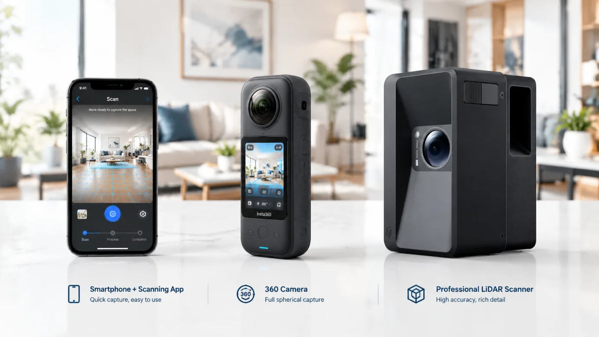
The right way to create a 3D tour depends on your project goals, budget, and the deliverables your clients expect. A mobile phone works well for basic property overviews. A dedicated optical camera provides steady quality for high-volume real estate listings. A professional laser scanner delivers exact precision required for commercial spaces and architectural workflows. You need to match the tool to specific output requirements.
Why Your Virtual Tour Capture Method Matters
Aligning your hardware choice with your specific business goals is essential. The equipment you use directly affects your daily operations. Choosing the wrong tool often leads to wasted time on site and disappointed clients.
Impact on Field Efficiency
Different devices require vastly different operational procedures. A lightweight setup lets a real estate agent finish a small residential property in ten minutes. The user simply walks through the room and taps a button. More complex hardware takes longer to set up and move between stations. The tradeoff is spending extra time on site to capture highly detailed spatial data that clients can use later.
Influence on Final Output Assets
Your hardware choice largely determines your final deliverables. A basic optical lens captures flat visual panoramas for simple web viewing. A sophisticated laser tool generates precise point clouds and architectural blueprints. You have to select hardware capable of producing the exact file formats your clients demand. A commercial broker expects floor plans with accurate dimensions. An optical camera alone might fail to deliver that level of detail reliably.
Brand Image and Client Trust
Your equipment signals your level of professionalism to your clients. Arriving at a luxury property with professional-grade hardware builds immediate trust. Clients feel confident that they hired a serious agency. A basic phone setup might work functionally well. The perceived value of your work links directly to the sophisticated tools you utilize.

Mobile Capture Solutions for Quick Projects
Any hardware comparison should start with the most accessible option: the smartphone. Many professionals already carry a capable camera in their pocket.
The Ideal User Profile
Mobile hardware suits beginners and teams operating with tight budgets perfectly. Real estate agents can create simple tours without buying additional equipment. The Realsee VR App turns a standard smartphone into a highly capable scanning tool. You can easily produce free virtual tours to test the local market. The barrier to entry drops to near zero.
Operational Advantages
Portability stands out as the most obvious benefit in the field. You always have your phone ready for impromptu shoots or unexpected client requests. The learning curve remains incredibly low. Anyone who can take a standard photograph can operate the mobile application. The software handles the complex stitching process automatically in the cloud.
Known Hardware Limitations
Quality relies heavily on your specific phone model and the ambient lighting conditions. Complex or dark rooms often look grainy compared to dedicated optical devices. The field of view is more limited. Users need to move carefully to capture a complete spherical image. The lack of active depth sensors means spatial measurements rely entirely on visual estimation algorithms.
Best Application Scenarios
Small residential homes benefit most from phone scans. Renters and buyers can get a quick feel for a basic layout. Landlords can document the condition of an apartment before a tenant moves in. Do not rely on mobile devices for precise architectural measurements or commercial deliverables.

Dedicated 360 Camera for a 3D Tour
A step up from a phone brings us to purpose-built hardware. Dedicated optical devices bridge the gap between amateur attempts and professional daily workflows.
Consistent Visual Fidelity
People often ask how to create 360 virtual tour content that looks truly professional. A dedicated camera provides uniform lighting handling and crisp details across the entire frame. The dual lenses capture a whole room instantly with a single click. You eliminate the awkward stitching errors commonly seen with basic phone applications. The dynamic range improves significantly. Windows retain their exterior views without blowing out into white blobs.
High Volume Operational Efficiency
Real estate photographers frequently shoot multiple properties in a single day. Speed is highly crucial for maintaining a profitable business. Many professionals search for the best 360 camera for real estate to speed up their daily operations. A connection to a compatible camera via the Realsee platform streamlines the entire creation process. The photographer moves quickly from room to room. The device captures the full spherical data in seconds.
Practical Business Value
Agents frequently wonder how do you make a 360 virtual tour quickly between client meetings. A standalone device provides the definitive answer. It represents the best 360 degree camera for real estate agents who need reliable results every single time. The upfront investment pays off quickly through faster property turnover and better online engagement. Sellers appreciate the polished presentation of their homes.
When a Professional LiDAR Scanner Is Worth It
The highest tier of capture equipment shifts the focus away from simple images. You enter the realm of precise spatial data and true digital twins at the professional level.
Advanced Spatial Data Collection
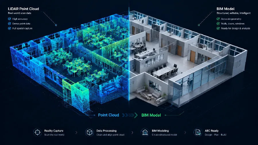
Visuals alone often fail to meet the rigorous demands of architects and engineers. A point cloud scanner measures physical dimensions with incredible accuracy. The active laser pulses bounce off surfaces to map the exact geometry of a room. The resulting data set contains millions of precise coordinates. Every single wall, door, and ceiling fixture gets mapped exactly as it exists in reality.
Hardware Options for Professionals
The Realsee Galois P4 and Galois M2 devices cater directly to strict professional standards. The P4 models capture dense point clouds and high-resolution visual data simultaneously. Users get millimeter-level accuracy for complex commercial environments. The M2 offers exceptional detail with a slightly different operational footprint. Both devices elevate the final output far beyond simple photography.
Engineering and AEC Outputs
A true 3d point cloud scanner unlocks entirely new business models for service providers. You can export the spatial data directly into standard CAD software. Floor plans generate automatically with exact measurements. These assets serve construction teams and facility managers long after the initial scan finishes. Contractors use the data to verify site conditions without traveling back to the property.
Commercial Real Estate Applications
Commercial brokers face unique challenges when leasing large office spaces. Prospective tenants need to know if their furniture will fit accurately. Precise laser scans allow remote clients to measure walls and plan layouts confidently. The high-resolution imagery shows the exact condition of the HVAC systems and ceiling grids.

Comparison By Specific Industry Use Case
An examination of distinct industries highlights the particular strengths of each hardware type. You can align your gear perfectly with your specific client base.
The table below summarizes the ideal pairings in a simple format.
| Industry | Recommended Method | Primary Reason |
|---|---|---|
| Real Estate Listing | 360 Camera | Balances speed and image clarity perfectly for standard homes. |
| Luxury Property | LiDAR Scanner | Requires ultra-high resolution to highlight premium material details. |
| Commercial Real Estate | LiDAR Scanner | Demands precise floor plans for leasing and complex space planning. |
| AEC and Construction | LiDAR Scanner | Needs tight accuracy for BIM integration and CAD workflows. |
| Museum and Tourism | LiDAR Scanner | Demands immersive realism and high-fidelity texture reproduction. |
| Retail Showroom | LiDAR Scanner | Depends heavily on the overall scale and complexity of the store. |
The data above illustrates a clear trend across different sectors. Professional applications lean heavily toward laser-based hardware. Casual marketing efforts succeed perfectly well with basic optical cameras. You must evaluate the specific expectations of your target audience. A retail manager might just want a visual walkthrough. An architect will demand actionable spatial data.

A Simple Decision Framework for Hardware Selection
You must evaluate your business model thoroughly before purchasing expensive equipment. A structured approach prevents costly hardware mistakes and protects your cash flow.
Assess Your Budget Constraints
Financial resources often dictate the logical starting point. Teams with zero hardware budget should start with mobile applications immediately. You can test client demand without taking on financial risk. An upgrade later makes sense once your tour-related revenue increases predictably.
Evaluate Your Client Demands
Listen closely to the people paying for your final product. A residential agent might only want a smooth visual walkthrough for social media. An architect will likely reject a tour if it lacks an accurate point cloud file. Match your financial investment to the specific deliverables your clients actually buy.
Analyze Your Volume Requirements
Think about the number of properties you plan to scan each week. A phone works fine for one house a month. A dedicated optical device becomes necessary if you shoot three houses a day. The time saved on site quickly pays for the dedicated hardware.
Plan for Future Service Expansion
Think about where your business will operate next year. A cheap optical camera saves money today. It might lock you out of lucrative commercial contracts tomorrow. Realsee offers a highly scalable path from basic phone captures all the way up to Galois laser systems. You can grow your capabilities naturally as your client base matures.
Choose the Right Setup for Your Next 3D Tour
Select the hardware that perfectly aligns with your daily projects. A phone offers a fast entry point for basic tours, a 360 camera improves consistency for regular listings, and a professional LiDAR scanner supports projects that need accurate spatial data and higher-value deliverables. Once you know what you need to capture, you can choose virtual tour software that supports the way you want to share and manage the finished tour.
Frequently Asked Questions About Mobile Capture vs 360 Camera vs
Q1: Does a mobile phone accurately capture high dynamic range lighting in rooms with large bright windows?
No. Standard smartphones struggle significantly with extreme lighting contrast. The small sensor often blows out window details or underexposes dark interior corners.
Q2: Will a standard dual-lens camera provide reliable millimeter measurements for structural engineering purposes?
No. Optical devices rely purely on visual estimation algorithms that fall short of professional tolerances. You must use hardware equipped with an active laser sensor to achieve reliable engineering accuracy.
Q3: Does the software platform charge a mandatory monthly subscription fee to host scans created with the hardware?
No. The platform operates on a flexible pay-as-you-go credit system. Users only pay for the exact processing and active hosting resources they actually consume.
Q4: Can real estate agents export direct CAD files from a basic phone-generated tour?
No. Complex architectural deliverables require exceptionally dense spatial data points. Only hardware with dedicated laser mapping capabilities can generate the accurate geometry needed for computer-aided design files.
Q5: Do thermal variations in a room affect the accuracy of a laser-based spatial scan?
In theory, extreme temperature differences can slightly affect laser measurements by altering the refractive index of air. However, normal indoor temperature fluctuations have negligible impact on practical results in typical commercial real estate environments.