

How the Galois 3D LiDAR reconstruction pipeline resolves color bleeding, occlusion errors, and photometric seams in complex spatial scans.
In spatial computing and 3D digital twin workflows, the Realsee Galois professional LiDAR scanner pairs high-accuracy laser measurement with ultra-high-definition panoramic imaging. However, registering true-to-life color textures onto dense 3D point clouds in cluttered industrial or commercial spaces has long presented an algorithmic challenge across the reality capture industry.
Due to the physical baseline offset between the LiDAR emitter and the optical camera center, direct back-projection algorithms suffer from two chronic failure modes: parallax-induced color bleeding along depth boundaries, and photometric seam artifacts driven by cross-station exposure variations.
This technical article dissects the updated algorithm pipeline implemented within the Realsee Galois reconstruction engine: utilizing local Voronoi mesh penetration testing for visibility occlusion culling, solving sparse linear systems for global brightness compensation, and optimizing a local spherical smooth color correction field for photorealistic point cloud deliverables.
1. Point Cloud Visibility via Local Mesh Penetration
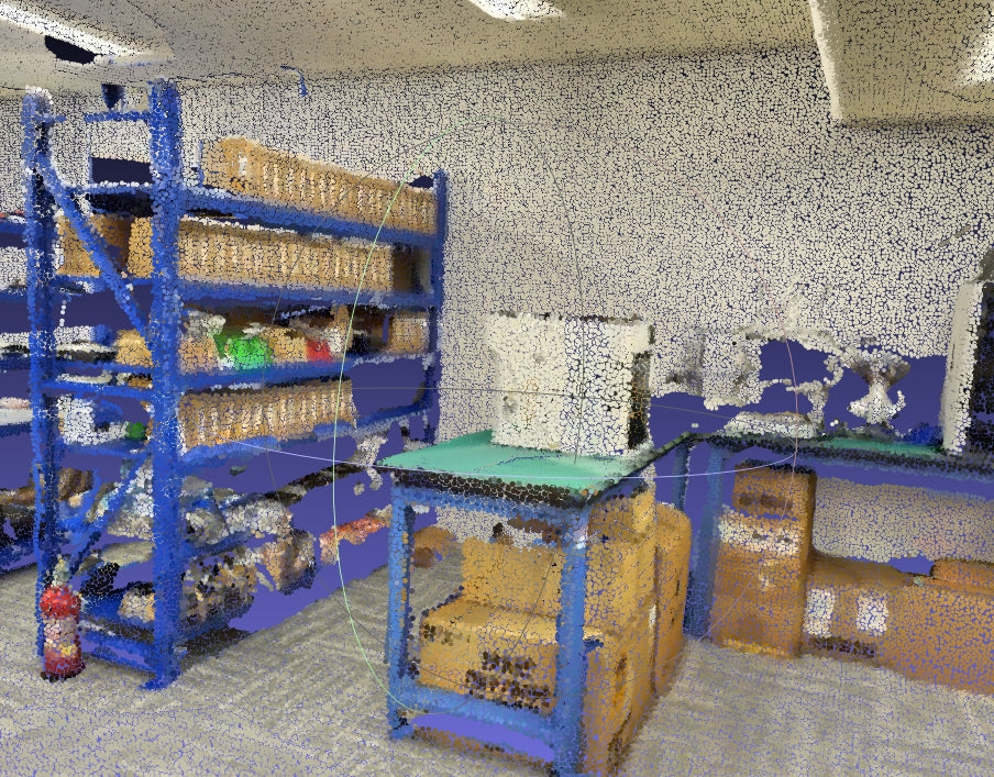
Direct 2D-to-3D projection consistently fails when lines of sight are obscured. When a background LiDAR point is projected back to the camera center, any occluding foreground object intercepts the visual ray. Without strict visibility verification, background points receive foreground color—such as white walls mistakenly tinted blue behind metal shelving.

Spatial Chunking and Local Mesh Reconstruction
- Voxel Chunking & Resampling: Points transformed to world coordinates are partitioned into fixed-size 3D chunks. Resampling ensure uniform point density and surface smoothness.
- Local Voronoi Meshing: Reconstructs local triangle meshes within each chunk, serving as geometric proxies for penetration collision tests.
- Hybrid Resampling: Surfaces are sampled and merged with original LiDAR points (with LiDAR points prioritized) to guarantee object-space uniformity.
Ray Penetration & Visibility List Truncation
For every hybrid sample point, nearest-neighbor LiDAR points are searched to extract scan station provenance. Virtual rays are cast toward candidate optical centers and tested against the local Voronoi triangle mesh. If a ray intercepts a triangle before reaching the target point, that viewpoint is flagged as occluded and pruned. The remaining valid viewpoints are sorted and truncated by viewing angle and distance to maintain a compact visibility list of length K per point.
2. Global Brightness Compensation
Variations in ambient illumination and automatic camera exposure (AE) introduce significant intensity discrepancies across capture stations, creating sharp seams across overlapping surfaces.
e = 0.5 * ∑i=1..n ∑j∈Oi Nij [ (gi Īij - gj Īji)² / σN² + (1 - gi)² / σg² ]
The first term enforces consistent average intensity across overlapping regions, while the second regularizes gains toward unity to prevent trivial solutions (configured with σN = 10 and σg = 0.1). Taking the partial derivative yields a symmetric, positive-definite sparse linear system A · g = b, which is solved efficiently via LU decomposition to determine optimal brightness coefficients for every station.
3. Spherical Smooth Color Correction Field
Global brightness scalars resolve macro exposure, but cannot eliminate localized chromatic drift or lens vignetting. To achieve seamless uniformity, a continuous sparse color correction field is solved across a unit sphere mesh consisting of 642 vertices.
 (a) Unit Sphere 642-Vertex Triangular Mesh
 (b) Rasterized Face Index Map (Left) & Barycentric Coordinates Map (Right)
-
Barycentric Field Interpolation: Panoramic pixels are rasterized onto spherical triangles, extracting color offsets via barycentric coordinate interpolation:
U(i,j) = b₀·us + b₁·up + b₂·uq - Dual Laplacian Regularization: Geometric mesh Laplacians and image-space pixel Laplacians enforce smooth color transitions without introducing synthetic boundary artifacts.
- Cross-View Color Consistency: For each point, the target color is formulated as the mean of its K visible stations. Offsets are solved via least-squares optimization to achieve global consistency across all setups.

4. Benchmark & Quality Assessment
| Evaluation Metric | Direct Back-Projection | Realsee Galois Pipeline |
|---|---|---|
| Edge Bleeding Rate | Severe (Walls tainted with foreground colors) | Near Zero (Occluded sightlines culled via mesh test) |
| Cross-Station Seams | Noticeable exposure steps | Seamless (Global brightness & smooth color fields) |
| Structural Detail Fidelity | Degraded boundaries and chromatic noise | Survey-Grade (Sharp, artifact-free textures) |
Frequently Asked Questions (FAQ)
How does Realsee Galois eliminate point cloud edge color bleeding?
Realsee Galois integrates local Voronoi triangle mesh ray-penetration tests. Prior to projecting 2D camera pixels onto 3D laser points, the algorithm traces light paths to identify whether an object (such as a shelf pillar) obstructs the view. Occluded camera views are automatically pruned, guaranteeing that background points never absorb foreground colors.
How does Galois achieve color uniformity across multiple scanning setups?
Galois applies a two-tier photometric pipeline: first, Global Brightness Compensation balances macro exposure differences across setups; second, a Spherical Smooth Color Correction Field mapped across a 642-vertex unit sphere optimizes chromatic offsets to ensure smooth, seamless transitions without boundary blur.
Can sensor hardware co-axial alignment eliminate the need for this algorithm?
No. In full 360-degree spatial scanning hardware, perfect optical co-axial alignment across both LiDAR and panoramic cameras is physically unfeasible. Intelligent algorithmic occlusion reasoning and smooth color field correction are essential for producing clean, CAD-ready .PLY and .E57 deliverables.
References & Further Reading
- Brown, M., & Lowe, D. G. (2007). Automatic panoramic image stitching using invariant features. International Journal of Computer Vision (IJCV).
- Sorkine, O. (2005). Laplacian mesh processing. Eurographics State-of-the-Art Report (STAR).
- Chen, J., Paris, S., & Durand, F. (2007). Real-time edge-aware image processing with the bilateral grid. ACM Transactions on Graphics (SIGGRAPH).