


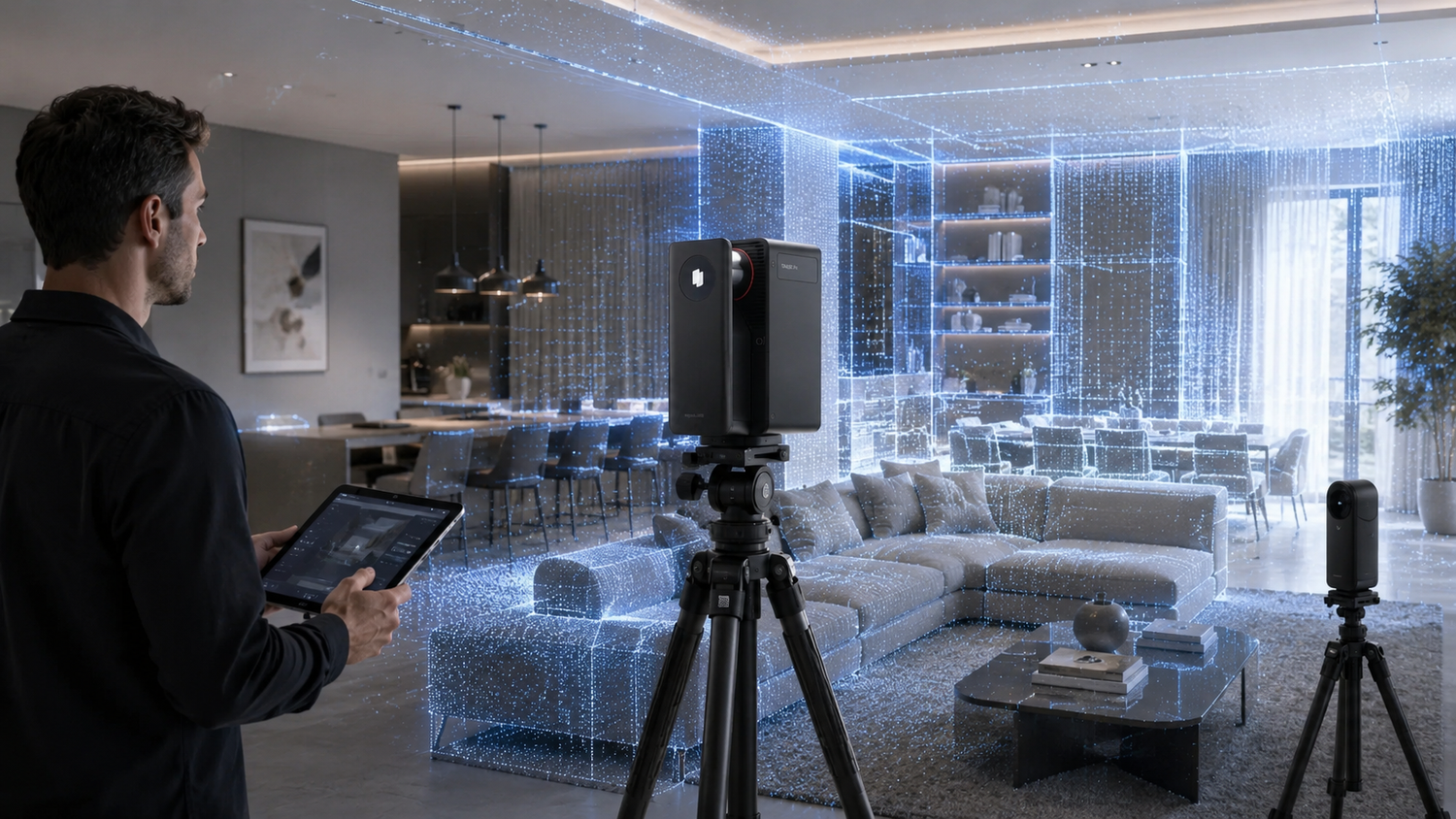
Spatial capture equipment heavily dictates the quality of digital twins. A 360 camera works beautifully for basic visual presentations of small residential homes. A LiDAR scanner remains necessary for complex commercial spaces requiring precise geometric data.
Professionals must match their hardware to specific project needs. The right tool depends directly on whether you need visual immersion or strict dimensional accuracy.

What Is a LiDAR Scanner
Let us look at the core technology behind precision spatial capture. A LiDAR scanner measures physical distances by illuminating a target with active laser light. The sensor calculates the exact time it takes for the light pulse to bounce back from a surface. This rapid process happens millions of times per second. The equipment generates highly accurate structural data based on the speed of light. Traditional cameras capture ambient light to create a flat visual representation. Laser technology records the exact physical dimensions of a room.
Laser Measurement Technology
The hardware operates by emitting rapid pulses of laser energy. These invisible beams strike walls, furniture, and architectural features. The device measures the reflection time to calculate precise distance vectors. The continuous rotation of the sensor maps the entire surrounding environment. The system functions flawlessly regardless of the ambient lighting conditions in the room. Operators can map completely dark basements or brightly lit showrooms with equal precision. The active light source guarantees consistent measurement accuracy across different environments.
Generating Dimensional Data
Professionals utilize a 3d point cloud scanner to map environments with millimeter precision. The device builds a dense web of coordinates in three-dimensional space. These collected coordinates form a precise digital replica of the physical world. Every single point contains exact physical location data. The resulting data sets form the foundation for advanced architectural modeling. Architects rely on this geometric truth to plan renovations and structural changes. The dense data provides a transparent and verifiable record of the physical site.
What Does a 360 Camera Capture
We can contrast laser measurement with purely visual photography methods. A 360 camera captures light from all directions simultaneously to create an image. The device relies on multiple fisheye lenses to record a complete sphere of visual data in one exposure. The internal software stitches these separate images into a single panoramic view seamlessly. Users navigate through these connected images to experience an immersive digital walkthrough. The process relies on visual perception rather than strict physical measurement. Viewers get a realistic sense of being inside the room without knowing the exact dimensions. The primary goal centers on aesthetic presentation.

Visual Spheres
The lenses capture a wide field of view in a fraction of a second. High dynamic range processing balances the exposure between bright windows and dark shadows. The camera merges multiple exposures to retain details across the entire scene. The final image file presents a continuous loop of visual information. Viewers can pan up to the ceiling and down to the floor. The visual immersion creates a compelling online experience for potential buyers. The technology democratizes the ability to showcase physical locations remotely.

Software Integration
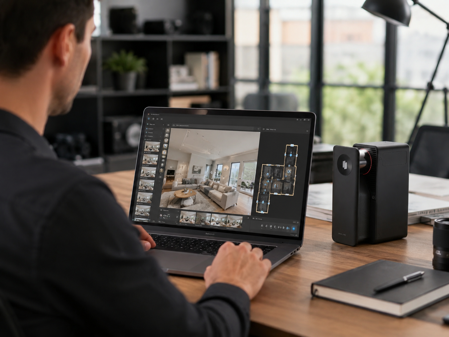
You can learn how to create 360 virtual tour experiences quickly with accessible tools. Realsee supports mobile capture workflows for rapid deployment on site. The Realsee VR app connects directly with mainstream panoramic cameras. Users sync the hardware with the platform to generate digital environments effortlessly. The software handles the complex stitching and alignment process automatically in the cloud. Agents can publish a complete property walkthrough in a fraction of the time required for traditional photography. The simplicity empowers marketing teams to digitize properties at scale.
Key Differences Between LiDAR Scanners and 360 Cameras
Hardware selection demands a clear evaluation of technical differences. We must analyze how each device processes and delivers spatial information. The variance dictates the final product delivered to the end client. The distinction lies in what the machine actually records during the capture process.
Data Types and Outputs
Panoramic cameras capture light pixels to generate a flat image. Laser devices capture spatial geometry to generate XYZ coordinates. The resulting deliverables differ significantly in their utility. Photography equipment outputs a visual panorama or a basic web-based tour. Point cloud scanners output precise geometric data files. Clients receive dense point clouds alongside CAD files and accurate floor plans. The geometric data allows engineers to slice through the digital model for cross-sectional views. Visual tours alone cannot support rigorous structural analysis.
We can summarize the fundamental differences between the two capture methods in the following table.
|
Feature Category |
360 Camera Capabilities |
LiDAR Scanner Capabilities |
|
Data Collection |
Captures ambient light pixels |
Emits lasers for XYZ coordinates |
|
Primary Output |
Panoramic images and visual tours |
Dense geometric spatial data |
|
Precision Level |
Low to medium dimensional accuracy |
High millimeter precision |
|
Ideal Environment |
Small residential properties |
Large commercial buildings |
The table highlights the distinct operational focus of each technology category. Project applications shift dramatically based on these capabilities. Standard photography suits property showcases designed to attract home buyers online. Professional surveying and AEC projects demand strict measurement tolerances. The initial cost and learning curve also differ. Standard cameras cost less and require minimal training. Laser equipment demands a higher initial investment and specific operational knowledge. Service providers must balance their equipment budgets against the specific needs of their target market.
When Is a 360 Camera Enough for Your Project
Specific scenarios justify the use of simpler visual technology. A basic camera fulfills the requirements for many everyday digital property listings. The key is matching the tool to the realistic expectations of the audience. Many clients simply want to see the layout of a home.
Small Residential Properties
Standard panoramic equipment excels in small residential settings. Real estate agents frequently search for the best 360 camera for real estate to market local apartments. These properties do not require millimeter-accurate architectural drawings. A fast visual capture provides enough context for a prospective renter or buyer. The digital environment gives viewers a clear sense of the room flow. A quick visual scan keeps the operational workflow efficient. Agents can scan a typical apartment in less than twenty minutes. The rapid turnaround time accelerates the listing process.

Budget Constraints
Budget constraints heavily influence the choice of capture equipment. Smaller agencies might lack the capital for high-end surveying gear. Accessible panoramic cameras provide a high return on investment for standard residential marketing. The lower price point allows an agency to equip multiple agents with their own devices. Agents can digitize a massive volume of properties with minimal financial risk. The final web-based walkthroughs look professional and engaging for the average consumer. The barrier to entry remains incredibly low for independent creators.
When Do You Need a Professional LiDAR Scanner
Complex environments require sophisticated measurement and robust data capture. Standard photography fails to meet the strict demands of professional engineering workflows. Professionals must deploy advanced laser systems to document large-scale physical spaces. The technology secures the geometric truth of the building.
Commercial and AEC Demands
Commercial real estate and AEC industries demand absolute precision. Massive warehouses and intricate museum spaces require professional laser point cloud scanning to document every structural detail. Engineers rely on these dense point clouds to generate accurate building information models. A slight measurement error can cause massive financial losses during a construction project. Laser systems eliminate the guesswork from the planning phase. The dense data sets provide a reliable foundation for all subsequent architectural decisions. Operators can measure distant ceiling beams and structural columns with absolute confidence. The spatial data serves as a permanent record of the site condition.
Advanced Deliverables
Advanced hardware delivers a comprehensive suite of professional deliverables. The Realsee Galois P4 serves as a prime example of a high-end spatial device. The system supports stunning 24K visual quality alongside dense point clouds. Users receive RAW images to ensure maximum visual fidelity. The data translates directly into precise floor plans and professional CAD deliverables. The hardware scans up to a 100-meter range with incredible efficiency. A single scan point takes roughly 16 seconds to complete. The rapid capture rate allows operators to map massive commercial complexes quickly. Professionals rely on this technology to build authoritative digital twins for their most demanding corporate clients. The open delivery model allows users to extract immense value from a single site visit.
Elevate Your Next Spatial Capture Project Today
High-quality hardware transforms how clients perceive physical properties online. Professionals can secure better projects by delivering accurate digital twins. You must select the appropriate equipment based on actual project demands. Evaluate your workflow carefully before purchasing new technology. Upgrade your capture methods to provide immersive virtual tours and reliable spatial data for your next major real estate or commercial client.
FAQs
Q1: Is LiDAR better than a 360 camera?
Yes, it provides superior dimensional measurement. A laser device measures physical depth while standard lenses only capture flat visual light. The superiority depends entirely on whether your project requires precise geometry or just simple visual presentations.
Q2: Can a 360 camera create a point cloud?
No, standard panoramic lenses lack true depth measurement capabilities. Software can estimate depth from flat photos to build rough models. True geometric precision requires dedicated laser sensors to plot millions of exact physical coordinates.
Q3: Do real estate photographers need LiDAR?
Usually no, basic visual immersion satisfies most home buyers. Standard panoramic equipment handles small apartments and average homes effectively. Laser precision becomes necessary only when clients demand accurate floor plans or detailed architectural documentation.
Q4: What is the best scanner for 3D virtual tours?
The Realsee Galois P4 stands out for massive commercial applications. It captures dense spatial data with a vast scanning range and generates premium panoramic visuals. Professional operators rely on such equipment to map complex environments efficiently.
Q5: What is the difference between laser scanning and 360 photography?
The primary distinction lies in data collection methodology. Photography records ambient light to create a visual picture. Laser technology emits active light pulses to measure exact physical distances and generate structural geometry.
Laisser un commentaire
Ce site est protégé par hCaptcha, et la Politique de confidentialité et les Conditions de service de hCaptcha s’appliquent.